- Pagina inicial /
- Eletrónica /
- GPS, Finders & Accessories /
- Sports & Handheld GPS /
- Handheld GPS Units /
- SMA26 Pro Rover GNSS Receiver RTK Surveying S...
0 ratings





Artigo n.º:
88112268
SMA26 Pro Rover GNSS Receiver RTK Surveying System with Controller and Software, Work as Base Station for Drones,10000mAh,32GB,4G/BT/WiFi,Ideal for
85% of respondents would recommend this to a friend
Artigo n.º:
88112268
STD 57922500
Detalhes do Preço
Excluindo custos de envio e alfandegários ( Os custos de envio e alfandegários serão calculados na finalização da compra )
*Todos os artigos serão importados de EUA
0 ratings
Escrever uma avaliação
Em stock
 Importado da loja USA
Qtd.:
Encomende já e receba por volta de Sábado, Setembro 26
Transação segura
A Ubuy trabalha arduamente para proteger a sua segurança e privacidade. O nosso sistema avançado de segurança de pagamentos garante a confidencialidade ao encriptar as suas informações durante a transmissão, utilizando os protocolos AES (Normas de Encriptação Avançada) e SSL (Camada de Sockets Seguros). Os seus dados de pagamento estão 100% seguros, pois não partilhamos os seus dados de pagamento com vendedores terceiros.
Os nossos principais Parceiros Logísticos


Obtain centimeter-level positioning accuracy with the compact and easy-to-operate SMA26 Rover.

Fast
Shipping

Devolução
gratuita*

Embalagem Segura

Produtos 100% Originais

Certificação PCI DSS

Certificação ISO 27001



Note: Step Down Voltage Transformer required for using electronics products of EUA store (110-120). Recommended power converters COMPRAR AGORA.


O que se Destaca
NOAA Certification
This product is NOAA certified, ensuring high standards in environmental data collection, which guarantees reliability and accuracy for professional users in surveying and research fields.
Handheld Convenience
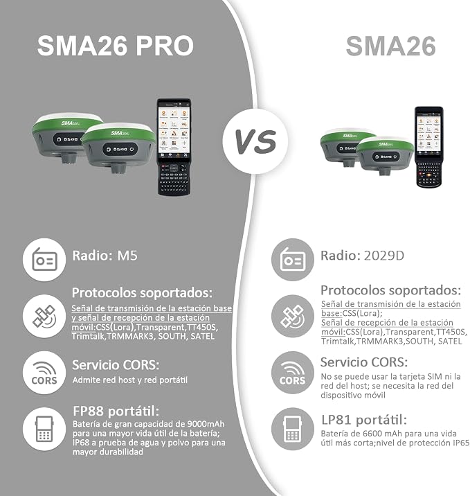
The LP81 handheld collector enhances mobility and ease of use, allowing users to collect data on-the-go without the need for cumbersome equipment, improving productivity in fieldwork.
Surveying Pole Included
The included surveying pole adds value and versatility, making it easier for users to achieve precise measurements and enabling seamless integration into various field applications, enhancing overall operational efficiency.
Detalhes do produto
| Screen Size | 5.45 inches (13.8 cm) |
| Additional Features | Touchscreen, Waterproof |
| Connectivity Technology | Bluetooth |
| Map Types | Worldwide |
| Battery Average Life | 2 days |
| Operating System | Android |
| Supported Satellite Navigation System | BeiDou, GLONASS, GPS, Galileo |
| Brand | SMAJAYU |
| Model Name | SMA26 4G Rover |
| Built-In Media | 1*2.2m Surveying Pole, 1*GNSS receiver;1*Handheld controller,1*Handheld bracket,1*Handheld Charger, 1*Power Adaper, 1*Terminal Antenna, 1*User Manual |
| Model Year | 2025 |
| Manufacturer | SMAJAYU |
| Number of Items | 1 |
| Model Number | SMA26 Rover with Pole |
| Special Feature | Touchscreen, Waterproof |
| Map Type | Worldwide |
| Included Components | 1*2.2m Surveying Pole, 1*GNSS receiver;1*Handheld controller,1*Handheld bracket,1*Handheld Charger, 1*Power Adaper, 1*Terminal Antenna, 1*User Manual See more |
| Battery Life | 2 days |
| Year | 2025 |
| Item Weight | 3.2 lbs (1.45 kg) |
O que está incluído na caixa
1*GNSS receiver;1*Handheld controller,1*Handheld bracket,1*Handheld Charger
1*2.2m Surveying Pole
1*Power Adaper
1*Terminal Antenna
1*User Manual
Quem Deverá Comprar?

-
Land Surveyors
This product is ideal for professional surveyors needing accurate and reliable GPS data collection for various projects.
-
Construction Managers
Construction managers will benefit from precise location data to optimize site layout and construction planning.
-
Environmental Researchers
Researchers can use this device for accurate geospatial data collection in studies related to environmental monitoring.

-
Casual Users
Not suitable for casual users looking for simple navigation or basic location tracking without extensive technical knowledge.
DESCRIÇÃO DO PRODUTO
Tem alguma Dúvida? Converse connosco
Perguntas e respostas do cliente
-
Pergunta:
What is the SMA26 RTK GNSS Surveying Equipment?
Resposta: The SMA26 RTK GNSS Surveying Equipment is a precision surveying tool that combines both a switchable base and rover system. This highly accurate GNSS receiver is designed for professional surveying tasks, allowing users to collect precise geospatial data in various environments. It operates efficiently with the included FP88 handheld collector, which simplifies data collection while incorporating a static 32G storage capacity to maintain all collected information. This setup is ideal for surveyors looking to improve accuracy and efficiency in fieldwork. -
Pergunta:
How does the switchable base and rover system work?
Resposta: The switchable base and rover system allows for flexible surveying projects. The base station collects satellite signals and transmits correction data to the rover, which is then used to collect position data. This coordination ensures enhanced accuracy, making it perfect for activities like land surveying, construction site measurements, and agricultural mapping. By utilizing this dual system, users can switch roles between the base and rover, depending on the specific requirements of the project. -
Pergunta:
What software is included with the SMA26 RTK GNSS equipment?
Resposta: The SMA26 package includes the FP88 handheld collector software, which is designed to streamline the data collection process. This software features user-friendly interfaces and organized reporting tools, making it easier for surveyors to analyze and interpret the collected data. Along with supporting various file formats, the FP88 software aids in efficient handling of surveying tasks, whether for mapping, infrastructure assessments, or land division projects. -
Pergunta:
What are the features of the FP88 handheld collector?
Resposta: The FP88 handheld collector is equipped with advanced features that enhance data collection effectiveness. It supports real-time data access, enables GPS signal processing, and has an intuitive touchscreen interface. The unit also provides GPS visualization, making it easier for users to track their positioning during surveys. This handheld device's capabilities are crucial for users working in remote locations or those who require rapid results in the field. -
Pergunta:
What is NOAA certification, and why is it important?
Resposta: NOAA certification indicates that the SMA26 RTK GNSS Surveying Equipment meets the standards set by the National Oceanic and Atmospheric Administration for accuracy and reliability in geospatial data collection. This certification is crucial for professionals, particularly those in sectors like environmental monitoring and federal projects, where precision is paramount. By using NOAA-certified equipment, users can trust that the data they collect is reliable and valid for sensitive applications. -
Pergunta:
What are the benefits of having 32G storage?
Resposta: The inclusion of 32G storage allows users to efficiently store large volumes of survey data without the need for immediate data transfer. This capability is particularly beneficial during extensive fieldwork, where transferring data may not be feasible or timely. Users can easily aggregate and manage information, making subsequent data analysis more streamlined and efficient, which is essential for maintaining productivity in survey operations. -
Pergunta:
Can the SMA26 RTK GNSS be used in various environmental conditions?
Resposta: Yes, the SMA26 RTK GNSS equipment is designed to operate in a wide range of conditions, including densely vegetated areas, urban environments, and harsh weather. The robust design and high sensitivity of the GNSS receiver allow it to maintain signal integrity even in challenging environments. This versatility makes it an excellent tool for various applications such as construction, mining, and environmental research, ensuring reliable performance regardless of location. -
Pergunta:
How does the SMA26 RTK GNSS equipment enhance surveying accuracy?
Resposta: The SMA26 RTK GNSS equipment enhances surveying accuracy through its real-time kinematic GPS capabilities, which reduce positioning errors significantly. The system provides centimeter-level precision by integrating data from multiple satellite constellations and applying correction algorithms. This level of accuracy is essential for high-stakes projects in engineering, architecture, and land development, where precise measurements can influence project outcomes. -
Pergunta:
Where can I buy the SMA26 RTK GNSS Surveying Equipment in São Tomé and Príncipe?
Resposta: You can buy the SMA26 RTK GNSS Surveying Equipment, including its switchable base and rover with FP88 Handheld Collector, exclusively at Ubuy in São Tomé and Príncipe. Ubuy offers a wide selection of surveying tools and equipment, ensuring you get authentic products with reliable service and support. -
Pergunta:
What types of projects is the SMA26 RTK GNSS suitable for?
Resposta: The SMA26 RTK GNSS is suitable for a wide range of projects, including land surveying, construction site layout, civil engineering, and agricultural mapping. Its high accuracy and versatility make it an ideal choice for professionals needing reliable geospatial data for urban planning, environmental assessments, and infrastructure development. Users can trust this equipment for both small-scale surveys and large-scale projects requiring detailed measurements and data collection.
SMAJAYU Handheld GPS Units SMA26 Rover with Pole Editorial Review


Nenhuma análise editorial encontrada
Avaliações e Classificações dos Clientes
1 classificações de clientes
-
5 Estrela
100%
-
4 Estrela
0%
-
3 Estrela
0%
-
2 Estrela
0%
-
1 Estrela
0%
Avaliar este produto
Partilhe as suas ideias com outros clientes
Prós
- Highly accurate GPS performance
- NOAA certified for reliability
- Durable surveying pole included
- Lightweight and portable design
- User-friendly handheld collector
Contras
- Occasional software glitches
CONFIANÇA NA PLATAFORMA E SEGURANÇA DO COMPRADOR

JG
Jazz
Comprador verificado
“Easy to use and always helpful and sorts any issues I've had past and present”
1 September 2026 · via Trustpilot
EK
Emmanuel
Comprador verificado
“I always receive support when I engage customer service. Overall my experience with UBUY has been top notch. Keep up the good work.”
31 August 2026 · via Trustpilot
F
fnd
Comprador verificado
“The delivery was fast and the product came undamaged and authentic.”
29 August 2026 · via Trustpilot
LC
Leana
Comprador verificado
“Ubuy is extremely efficient and to order online is an easy process. The verity of products to buy is really unlimited! My order was urgent and I got it on time. The products are great! Thank you Ubuy!”
25 August 2026 · via Trustpilot
HL
Hengo
Comprador verificado
“Fast, convenient and cheap. Great store!”
27 August 2026 · via Trustpilot
Checkout Seguro
Entrega Global
Devoluções Fáceis
Produtos Genuínos
Histórico de preços do produto
Informação importante
- Limitações: para produtos expedidos internacionalmente, tenha em atenção que qualquer garantia do fabricante pode não ser válida; opções de serviço do fabricante podem não estar disponíveis; manuais de produtos, instruções e avisos de segurança podem não estar nas línguas do país de destino; os produtos (e materiais que o acompanham) pode não ter sido concebido em conformidade com as normas, especificações e requisitos de rotulagem do país de destino; e os produtos podem não estar em conformidade com a voltagem e outras normas elétricas do país de destino (requerendo assim o uso de um adaptador ou conversor caso seja apropriado). O destinatário é responsável por garantir que o produto pode ser legalmente importado para o país de destino. Quando encomenda à Ubuy ou aos seus afiliados, o destinatário é o importador de registo e deve estar em conformidade com todas as leis e regulamentos do país de destino.
- Nem todos os produtos listados na Ubuy estão à venda, uma vez que a Ubuy é um motor de busca global. Os produtos estão sujeitos a leis de exportação/comércio.
STD 57922500
Encomende já e receba por volta de Sábado, Setembro 26
Este artigo não está restrito no meu país. (Clique no link acima se este artigo não estiver restrito no seu país, para que a nossa equipa o analise e permita.)
Qtd.:
Transação segura
Em conformidade com a norma PCI DSS e com certificação ISO 27001:2022, com pagamentos encriptados e proteção total do comprador em todas as encomendas.
Os nossos principais Parceiros Logísticos
Entrega internacional mais rápida
Recursos e benefícios
- Compact and portable design for easy operation.
- Delivers centimeter-level positioning accuracy with GNSS global corrections.
- Built-in 10000mAh battery ensures extended usage.
- Features base station and rover mode for versatile applications.
- Equipped with Bluetooth and wireless modules for connectivity.
- Inertial navigation with automatic pole tilt compensation.
Ubuy Assurance
Experience worry-free shopping with 100% original products, PCI DSS-compliant payment security, ISO 27001-certified data protection, the fastest cross-border delivery, free returns *, and secure packaging on every order.